Description
This section is a short summary of SPROUT D4.9: Impact assessment and city specific policy response.
Budapest Pilot
The distribution of urban space, which is very much in favour of car transport, is more and more questioned in cities; due to concerns about air pollution, noise and greenhouse gas emissions, traffic safety, or liveability of cities.
In the Budapest Pilot on urban space re-allocation, road traffic was banned from a street segment in the city centre. Only authorised and freight traffic was permitted within the new pedestrian zone. In addition, approximately 40 parking places were closed. After the pilot phase, stakeholders decided to keep the pilot changes. Because of the success of the pilot, the two neighbouring districts decided to rebuild this section in the next few years in order to create a permanent pedestrian zone.
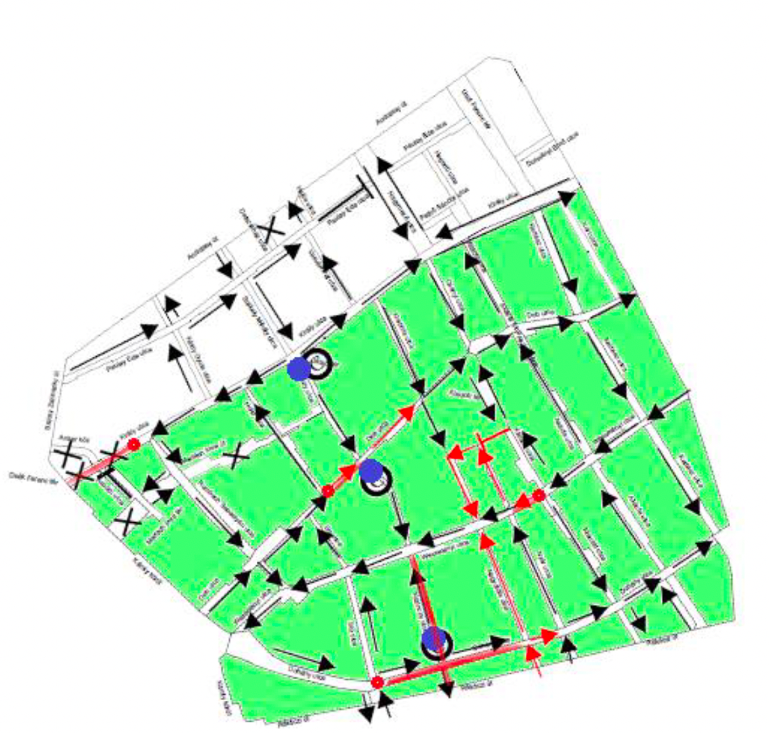
Source: SPROUT D4.9, p.16. Red arrows indicate changes in traffic management
No physical barriers were installed to avoid traffic at the entrance of the street, only traffic signs were used. In addition to the pilot project, there have been major changes in terms of through-traffic management. This means that traffic was minimised within a wider area by reorganising the direction of traffic flow along several residential and arterial roads.
The Budapest pilot gave an opportunity to explore the results of a downtown district’s traffic calming. The objective of the traffic calming was to make the district more liveable and to divert traffic to the main roads bordering the district. The additional goal was to increase the share of active mobility and increase safety of vulnerable road users.

Cost depend mostly on the degree to which construction works are implemented: If the street were completely redesigned (creation of green areas and of a community space), the costs would be higher, but the benefits would also increase. Compared to the costs of traffic calming in Király utca, the benefits should be found to be much higher based on user feedback. The financial and economic analysis found that benefits of the pedestrianisation outweigh the costs, even if the streets were completely redesigned (creation of green areas and of a community space).
In order to derive a data basis for the impact assessment, different collection methods were used. Gehl’s stationary activity mapping (https://gehlpeople.com/tools/stationary-activity-mapping/) allowed measuring the usage of public space; conventional traffic counting for measuring the different types of vehicles; air pollution measured with data on airborne dust and NOx concentrations Finally, surveys and local workshops were conducted to collect feedback from citizens and stakeholders to measure the effects of the pilot and compile relevant information for understanding how cargo loading methods and behaviours changed.
Measuring the impact of the pilot was quite challenging. More specifically, due to the strict lockdown during the pandemic, all restaurants and stores were closed, while gatherings in groups in public spaces were restricted from 8 March 2021, and a curfew between 8 p.m. and 5 a.m. was introduced from 11 November 2020. That means that although the initial scope of the pilot was within the new pedestrian zone at Király utca to turn car parking spaces into public spaces that would be equipped with public and restaurant-owned chairs, benches, trees, etc. and then measure the acceptance of the measure by the public and the improvement in the quality of life, the pandemic related restrictions prevented people from testing the measure.
As a result of the pedestrianisation, significantly fewer vehicles drive into the examined section of Király utca compared to the previous period. In the place of closed parking lots, it is possible to create green areas and communal areas, thanks to which, the ecosystem of the street will become more sustainable. It is possible to retain rainwater for the planted vegetation. Moreover, reduced traffic has made the street safer for vulnerable road users. Due to the increase in safety, the investigated street also attracts vulnerable road users from the surrounding streets.
The formulation of policy responses follows a Stakeholder-Based Impact Scoring (SIS) approach. The following paragraphs outline the results and findings from applying this method to the Budapest pilot case.
Practical information on the SIS approach is provided under the section Analysis Phase and Policy Responses
Several meetings with the stakeholders and public forums were organised during which residents and local stakeholders could state their opinions. The main issue that should be addressed through the pilot was the high car traffic volume in the area, leaving not enough space for pedestrians, cyclists, and micromobility users. The suggested solution was to establish city-wide planning standards, forcing planners to plan sufficient space for all modes of mobility.
The main problem encountered during the implementation was the initial strong criticism of the project from residents, shop owners and visitors, complaining about the difficulties entering the area with a private car or delivery vehicles. However, within a few months, the criticism decreased, and locals started to support the project, as they realised that streets became calmer, safer and more liveable. Due to the reduced number of private cars, it became easier for delivery vehicles to find free parking spots to serve local shops and restaurants. They also occupied significantly less space on the sidewalks.
Several decision-makers, who opposed the project in the beginning, also changed their opinion during the project. Stakeholders agreed to keep the changes made during the pilot phase. There are plans now to extend the traffic calming area and create a so-called super block with streets only open for pedestrians, cyclists and authorized vehicles. Therefore, the pilot helped to increase the citizens’ and local authorities’ acceptance.
Problems were also encountered with unauthorised motorists ignoring the access restrictions and with controlling entry permits for vehicles. City authorities consider introducing camera surveillance to control entry permits for vehicles.

The relevant stakeholders that participated in the selection and assessment of policy response and their stated criteria (aspects they find particularly important) are listed below:
| Public transport operator |
Economic sustainability of operations Social sustainability of operations Environmental sustainability of operations Increase in MaaS use Decrease of the environmental impact of transport Decrease in private car use |
| Mobility operators |
Increased support for shared mobility Economic sustainability of operations Social sustainability of operations Environmental sustainability of operations Decrease of the environmental impact of transport Increased share of eco-friendly transport modes |
| Infrastructure department |
Economic sustainability of operations Environmental sustainability of operations Coherence of the public space configuration Increase in road safety Simplification of maintenance work |
| Walking or cycling associations |
Coherence of the public space configuration Increase in safe infrastructure for micromobility users Increase in modal shift Decrease of the environmental impact of transport |
| Users of micromobility services |
Reliability of the service Decrease in traffic Coherence of the public space configuration |
Building on the previous steps and the policy solutions that went into the alternative scenario, SPROUT partners derived a list of policy responses based on the SPROUT policy inventory. The following policy measures have been suggested. The policy package comprises of two measures to foster the integration of passenger and freight transport and two measures that institutionally support the integration.
To enhance the positive impacts of the mobility solution, the following policy responses have been considered and selected by stakeholders:
- PM1: Advantage of active transport over individual motorized transport.
- This measure is at the core of the pilot. While it met initial criticism from residents, local stakeholders and politicians, acceptance increased during the project phase and it was decided to maintain and to eventually extend the pilot area.
- Access restrictions should not only be communicated via signs but also through street design. The city of Budapest is considering monitoring access restrictions using cameras.
- PM2: Provision of leisure activities, green surfaces, street furniture:
- Alternative uses of removed car parking spaces should be implemented, for example through green areas and trees, bike parking facilities, street furniture (benches, seating), of permitting restaurants to build terraces.
- Additional costs will arise for the procurement, installation, maintenance, and operation of street furniture and green spaces. This requires a definition of responsibility for implementation, operation, and maintenance costs, such as a cost-sharing agreement between road operators, city districts, and the city government.
- Costs can be reduced using standardisation.
- PM3: Measures to give priority to public transport
- This measure will promote public transport instead of individual motorized transport.
- Strengthening alternative mobility options is complementary to pedestrianisation and removing car parking spaces since it increases acceptance. It aligns to achieve a more (space-)efficient mobility system.
- Costs arise from the creation of dedicated bus lanes and changes in traffic signal programs.
- PM4: Definition of measures and guidelines for transport in favour of certain modes of transport
- This is a specification of PM1.
- The involvement of different (public) actors, including the city administration, the districts, BKK, and different planning departments indicated the need to have unified and city-wide planning standards to reduce alignment processes between the city level and districts.
The suggested policy measures were then assessed through stakeholders, using the Recommended Indicators for Assessing Policy Implementation Feasibility and User Acceptance of New Mobility Solutions
Stakeholders concluded that the policy measures were mutually supportive. They also mentioned that PM4: ‘Definition of measures and guidelines for transport in favour of certain modes of transport’ was a specification of PM1: ‘Advantage of active transport over individual motorized transport’ was a sub-category. They also insisted that direct and indirect benefits of active mobility outweigh potential investment costs, although the positive impacts might be hard to establish (for example health benefits). Benefits would also accrue for local shop owners, profiting from more people in a more attractive environment. Regarding the priority measures for public transport, stakeholders claimed that active mobility, micro-mobility and public transport should re-inforce each other and not be placed in opposition to each other.
PM4 “Definition of measures and guidelines for transport in favour of certain modes of transport” is the most accepted and feasible policy measure to support the creation of mobility points. Stakeholders and users participating in the survey understand the measure. Moreover, they and consider it affordable, acceptable and feasible.
PM1 “Advantage of active transport over individual motorized transport” was criticised as the indirect costs make this measure financially unfeasible. However, the comments during the workshop emphasized the broader socio-economic and environmental.
PM2 “Provision of leisure activities, green surfaces, street furniture” was the most controversial measure. On the one hand it was mentioned that it requires more investments for providing and maintaining street furniture and green spaces, while potentially reducing the commercial activity to the local stores. On the other hand, it is argued that green spaces surrounding commercial areas and with micromobility points may raise the attractiveness of area and increase activity.
PM3 “Measures taken to give priority to public transport” may require high investment to create dedicated lanes and to change traffic signal programs. However, as active and micromobility is very seasonal and long-distance may reduce the acceptance, PM3 complement and reinforces the creation of pedestrian zones and may increase the cultural change towards more active, shared and eco-friendly mobility.
To conclude, all the alternative policy measures explored for the installation of micromobility points will help to accept it and scale to other neighbourhoods. The combination of these PMs with the creation of micromobility points will ensure and speed up the transition towards Budapest new mobility in the long term.
Key learning and recommendations
The following key messages were derived from the pilot:
- To increase the use of space for leisure activities anticipate the permissions of restaurant for installing terraced in the vacated parking spaces and set up benches, street furniture, bicycle racks, points on the place of closed parking slots.
- Create cooperation between the public transport and the shared mobility modes.
SPROUT materials and tools
Other relevant tools and methods
Information on Stationary Activity Mapping method: https://gehlpeople.com/tools/stationary-activity-mapping/
Further information
Budapest Mobility Plan: https://bkk.hu/en/strategy/budapest-mobility-plan/
